George W Goyder
The Regional Council of Goyder was named in honour of George Woodroofe Goyder whose famous (or infamous) to so many early settlers in the area) "Goyder's Line" traverses the former District Council areas that now make up the single regional council.
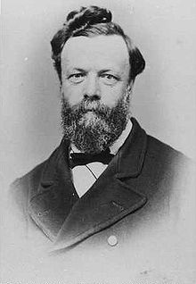
George W Goyder (1826-1898), was born in Liverpool and migrated to Australia at the age of 22 in 1848. He arrived in Adelaide in 1851, entered the public service and, in 1854, was appointed Deputy Surveyor-General for South Australia.
In 1857 he was sent with a party to check on some geographical discoveries of Benjamin Babbage, who was the South Australian Government Assayer.
Between the time of Babbage's earlier journey north and Goyder's trip, there had been some heavy rainfalls and the countryside was in full flower. Goyder, in contradiction of earlier assessments by Edward Eyre, was able to report with some amazement that Lake Blanche contained fresh waster and that the land was fertile. But he was a 'new chum' and easily deceived by this temporary lushness.
As a result of his optimistic account there was a rush of applications for leases in this 'promised land'. It was not long, however, before these pioneers of the north were sending back gloomy reports of barren, water less and useless tracts of land.
In 1865, following some years of drought, Goyder was sent north to determine the line of demarcation between where rainfall had extended and where the drought conditions prevailed. Thus was established the so-called "Goyder's line of rainfall" which followed the southern boundary of the vast salt bush areas of the north.
Goyder's line ran from a little north of Pinnaroo in a curve past Eudunda and Burra to Terowie, then between Yongala and Peterborough, then north-west to Mount Remarkable and south to Moonta. Goyder's Line provides a very accurate guide to the separation point between lands suitable for all sorts of agriculture on a long-term sustainable basis and lands suitable only for grazing.

Those settlers who did not heed the advice of Goyder eventually realised their folly as they were forced to leave their holdings to the pastoralists and take up land elsewhere. Goyder undertook other surveying trips, most notably to the Northern Territory (1868-69) where he surveyed the Darwin. The city has commemorated this work with a plaque. Goyder was also sent to England to procure machinery for putting down deep bores in search of water, a scheme for which he was an ardent advocate. He retired in 1893 and died five years later at Aldgate.